How VertexGIS Can Help
Our aim is to make your life easier.
At VertexGIS we specialise in GIS, Traffic Regulation Order mapping (TRO), TRO Web App provision and surveying services.
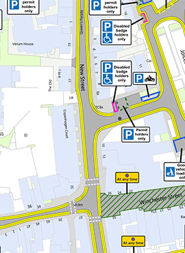
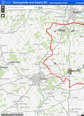
Cost is always important and that’s why we endeavour to provide the most cost effective solutions available. The quality of our mapping both in accuracy and aesthetically, is second to none. Inspect the quality for yourself by viewing the TROmapAp, with links to the pdfs.
We provide TRO Web App creation as well as on-site surveys, to help Local Authorities with their individual needs. We are extremely friendly, professional, knowledgeable and reliable. We will work closely with you to streamline your TRO process so that you can locate your data faster, work easier and achieve more.

VertexGIS offer the following services. If we can help with any of the services outlined below, we would love to have a chat, get to know you and offer you the very best VertexGIS TRO Data solutions.
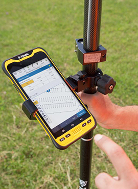
ON-SITE SURVEYS
We conduct on-site surveys, to ensure your TROs are accurate and enforceable
Learn More
TRO REVIEWS
Review your TROs so you can be confident that they reflect the restrictions on street
Learn MoreWho We Are
VertexGIS are a Geotech company offering cost-effective TRO data solutions to Local Authorities in the UK.
We began as JL Mapping Services working for Buckinghamshire, Bedford and several districts in Hampshire. We carried out surveys, produced map-based TROs for Local Authorities applying for CPE and also converted Local Authorities’ historic text-based and other GIS data into maps produced with Esri software.
It became increasingly evident that we needed to be able to offer an online interactive map to our clients. So, we developed an innovative, unique interactive Web App, launching it from the secure Esri Cloud platform. It was first made available online in March 2022 and we have had incredibly positive feedback. We are promoting it to Local Authorities as the most cost effective option for publishing their TROs online.
VertexGIS offer a high-quality package of TRO mapping, surveying, consultation drawings and full maintenance of TRO data, ensuring TROs are completely accurate and always up to date.
We are looking forward to meeting with many Local Authorities to discuss how VertexGIS can be of service.